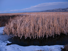
Desert Wetlands in Sunshine Valley as seen from Google Earth
Image searched and sized by Chris Cote
Image searched and sized by Chris Cote
One of the objectives for this project is to examine the wetlands in as many ways as possible, deepening and widening the experience of this particular place and my relationship to it. Exploring the wetlands through all four seasons is the major premise of the project, however using scale to determine observations and experiences could be another important and evocative method. By scale I mean relative size, extent, or degree in my approach, from macro to micro and everywhere in between; in essence a sort of observational measurement tool.
The word "scale" comes from Middle English and from Late Latin, scala ladder or staircase, from Latin, scalae, plural, stairs, rungs, ladder and is akin to the Latin scandere, to climb. Scale is about climbing the ladder of perception. Each rung provides a different perspective. If I look at the layout and land patterns of the wetlands on Google Earth I will get one type of information and experience,while sitting and listening to the red wing black birds will bring another, and looking at a water sample from the wetlands under a microscope will result in still another series of observations and experiences.
Most of my observations so far, have fallen somewhere between micro and macro, perhaps in the broad "meso" category. Throughout this project I hope to find many ways to climb between scales and to experience the different worlds revealed through a variety of perspectives. The image above is the first attempt at a more "macro" approach. Chris's dexterity with Google Earth and his interest in GPS and GIS will undoubtedly be of help as I attempt more macro observations.


